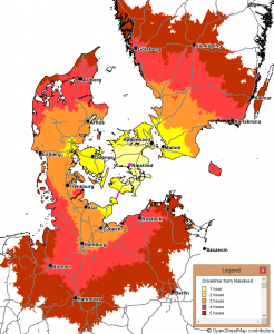
For the municipality of Næstved we have calculated drive time isochrones showing the effect of the Fixed link at Femern Belt, scheduled to open in 2021 and connecting Germany and Eastern Denmark. Calculations were done with RW Net 4, OpenStreetMap data and this coastline dataset. Almost one hour is expected to be saved on drive time, making Berlin reachable in 5 hours.
The fully detailed OSM has been used in the calculations, while only motorways and trunk roads are shown.
Maps has been created with MapInfo Professional.


